
This map can be found on page 9 of 39 of the
8/12/24 Draft Land Use Element
Transit Corridors
designated for high-density development
As part of the 2044 Comprehensive Plan drafting process, in 2024, the City of Kirkland proposed a policy that would significantly increase density for all land shown in red on this map.
In the proposed policy, the City designated seven new “transit corridors” that cut through almost all of Kirkland’s residential neighborhoods and covered around 25% of Kirkland’s area. Increased density was to be implemented in a half-mile corridor centered on each street (i.e., 1/4 mile off the street in each direction). The Kirkland Planning Commission and staff discussed densities ranging from 50 to 200 units per acre in these zones and draft documents noted building heights up to 6 stories. In contrast, existing residential neighborhoods in Kirkland typically have densities of around 5-10 units per acre.
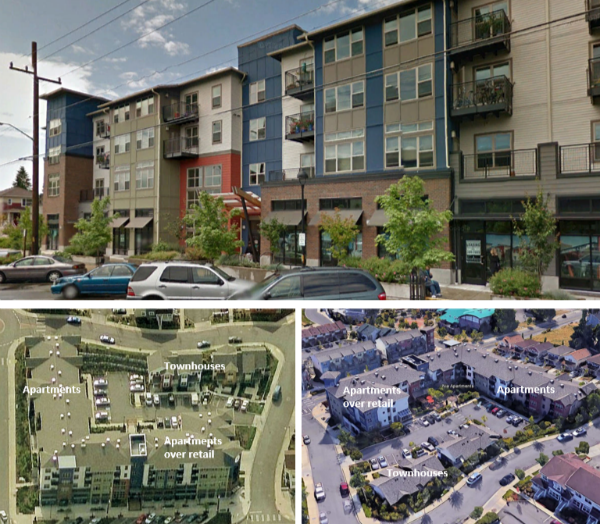
59 units per acre with retail and parking across the development

205 units per acre, achieved in a single lot via studio units and limited parking, near a light rail Transit center (TOD)
There was no realistic plan for how existing infrastructure would scale up to meet the demands of this infill building. Kirkland’s border with Lake Washington creates unique access issues compared to other local towns, limiting our ingress and egress points. Most of these “transit corridors” are one-lane roads and already bear heavy traffic. They would quickly become even more congested with a significant influx of new vehicles.
The City also pushed for decreased parking requirements in connection with this development. Without adequate parking spots, overflow parking would spill onto residential streets, hindering emergency vehicle access, reducing pedestrian safety, and impairing visibility. Expecting new residents to rely solely on public transit is unrealistic given that many of these neighborhoods lack convenient access to daily services (like grocery stores). Kirkland has historically had extremely low public transit adoption rates.
-
What was the City trying to modify?
The City proposed high-density development within existing low-density residential neighborhoods as part of its draft 2044 Comprehensive Plan.
If this proposal had passed, it would have required updates to city zoning codes to align with these high-density growth objectives.
For more details, you can review the Development Capacity Analysis completed by the City or explore the land use documentation and presentations from City staff at the link below.
-
Why did the City want this?
The City claimed this extreme change was required under Washington’s Growth Management Act. The Growth Management Act does require cities to meet certain growth thresholds, but Kirkland was projected to meet and exceed its state-mandated growth requirements with its existing zoning.
Per the City’s own study:
“This analysis shows that the City has more than enough capacity to accommodate its assigned growth targets, if we account for the growth the City has seen between 2019 (when targets were set) and 2022 (the analysis year).In 2044, the City is expected to have a surplus capacity of 6,234 housing units and 858 jobs above the King County growth targets. That said, it could be in the City’s interest to continue expanding capacity beyond what is needed to meet the growth targets and achieve important community-wide objectives such as housing affordability, better transit service, and reductions in per capita energy use.”
-
What were our main concerns?
The City’s goals are admirable, and many Kirkland residents agree with them. However, the City’s plan to haphazardly fill residential neighborhoods with high-density (likely luxury) developments didn’t appear to seriously address any of their stated concerns.
The high-density development proposed in our residential neighborhoods was excessive.
Proposed minimal parking requirements were insufficient for anticipated growth. Without adequate parking, and/or robust transit, overflow parking would spill onto residential streets.
Kirkland streets, already busy, would experience even heavier traffic, and neighborhoods would suffer higher rates of cut-through traffic as cars try to avoid clogged arterials.
Drastically increasing housing units would strain resources like water, electricity, and sewage with property-funded, scattered sidewalks and infiltration plans as band-aid solves.
Kirkand’s urban centers are better suited for high-density housing thanks to their close proximity to freeways, public transit hubs, and grocery stores.